Through the years the name of the village changed many times from Collaton Clavil to Coletone, to Coleton Clavill to Collaton Kirkham and finally to Collaton St Mary, when it became an ecclesiastical parish.
Coletone to Collaton Kirkham
The village is first mentioned in the Domesday Book, when it was classed as a sub-manor of the Manor of Peintona. In 1166 Alan de Furneaux held Collaton as his fee from the Lord Bishop of Exeter. When the above mentioned Alan died, John de Blakedon paid 100 shillings for the relief of the land of Coletone.
For over 400 years, members of two families held the lands of Collaton and nearby Blagdon. The Deneis family until about 1292, when the estate passed to Robert le Deneis' daughter Agatha who was married to Nicholas Kirkham of Ascombe.
The name of the village then changed to Collaton Kirkham in the honour of the family who lived there through 11 generations.
1630 saw the Kirkhams rule over Collaton and Blagdon end with the death of Richard Kirkham. His daughter Mary who was married to George Blount, heir to Sir Walter Blount of Soddington, Worcestershire inherited the estate. George and Mary's third son Edward carried out a complete restoration of the Kirkham family home.
The Parker Family
When Edward died the estate was sold to the Parker family of Whiteway, whose name the village Public House still bears, "The Parkers Arms".
Parish of Collaton St Mary

Collaton St Mary is an ecclesiastical parish which was formed in 1864, from the civil parish of Paignton.
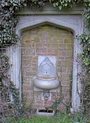
At the junction of Totnes Road and Blagdon Road is a drinking fountain, erected as a memorial to Percy Whitehead of Barton Pines (who died 13 February, 1897).
The wording on the fountain reads:
THIS FOUNTAIN IS ERECTED BY HIS FAMILY
TO THE DEAR MEMORY
OF PERCY WHITEHEAD
OF BARTON PINES COLLATON.
DIED FEBRUARY 13 1897
The Paignton to Totnes Road
Collaton St Mary lies on the road from Paignton to Totnes, about two miles west of Paignton town centre and 4 miles east from Totnes; it is about 5 miles south-west of Torquay.
In 1809 the road from Paignton to the west followed the line of the present Totnes Road to Collaton Kirkham (Collaton St Mary) then via Blagdon Road to Berry Pomeroy to rejoin the present Totnes Road at True Street. At this time the whole length of the road from Paignton to Totnes was known as True Street.
The present Totnes Road between Collaton St Mary and Longcombe existed as a lane and continued south of the present road to join at the top of Bridgetown Hill.
The date at which the present Totnes Road, by widenings and diversions, became a turnpike road is not known, but the road on its present site is shown on maps about 1830. The turnpike gates on this length were at Collaton (junction with Blagdon Road) and True Street where the Toll house still exists.
At the end of 1943 arrangements were made for the widening of certain main routes to a width of 22 feet by the military*, including Totnes Road at Beechdown Hill, a widening that the council had pressed for years before the war without success - one of the principal arguments against a widening being the loss of some trees. No such consideration deterred the military and after widening, the councils contention was proved, the view of Blagdon Valley then revealed, outweighed any beauty the trees may have had.
Two County Road improvements were undertaken in 1950 widening and verge construction in Totnes Road between Battersway Road and Tweenaway Cross and at the end of 1951 the length of Borough Road to Parkers Arms was being widened, providing a continuous footpath from Paignton to Collaton.
*This is believed to be the US Army, in preparation for practice manoeuvres for the D-Day landings, at Slapton. The tanks were moved in a convoy through Collaton village.
